Ian MacRae
University of Minnesota, Crookston
Northwest Experiment Station and Agricultural Management Division
Agriculture has always adopted new technologies as they have become economical. Larger and more powerful engine and mechanical systems have led to larger, more powerful and more efficient farming equipment. In pest management, the development of resistant varieties, selective pesticides, and transgenic crop varieties have all been readily adopted into commercial agricultural production. Probably the greatest decrease in cost coupled with an accompanying increase in performance has been seen in the computer industry. I recall seeing a sign in a computer science lab in the mid 1970's stating that if the auto industry had made the same technical advances in the previous 10 years in their products as had the computer industry, a Rolls Royce would cost $25 and get 125 miles to the gallon. I suspect if that statement were to be rewritten today, you'd be paid several thousand to take the car and it would get twenty miles to the drop. The computing power in personal computing systems is staggering when compared to midi- and mini-computers of 20 years ago. This increase in available and economic computing power has made it possible to run software applications on desk top systems which previously had been the realm of large mainframes. This in turn has made available several digital tools which can now be economically applied to production agriculture.
Digital tools such as Geographic Information Systems and Global Positioning Systems allow very precise mapping of agricultural areas. These technologies, combined with soil mapping and yield monitors have led to the production methods referred to as "Precision Agriculture" (sometimes also called Prescription Agriculture). The basis of Precision Agriculture is applying agrochemicals only where necessary. The point of Integrated Pest Management is to apply pesticide only when it's necessary. By using these technologies in IPM, we can develop "Precision IPM", only applying pesticides where and when it is necessary. This chapter will provide an overview of some aspects of GIS and Global Positioning Systems (GPS) and provide some suggestions as to their possible use in IPM. Some additional readings and links to other WWW sites which can provide further information are also included in the text.
What are Geographic Information Systems (GIS)?
Geographic Information Systems are essentially relational databases. The relationship between items in the database are their locations, either in real-earth coordinates (e.g. UTM, or longitude/latitude), or on a grid (i.e. X,Y coordinates). GIS combine digital mapping, database functions, and spatial analysis. Basically, GIS are computer software packages that are capable of assembling, storing, manipulating, and displaying geographically referenced information. The system itself includes the operator. As with any computer program, a GIS cannot confirm the quality of the data being input or interpret the output. These two tasks require an operator familiar with the field for which the digital tool is being used.
The difference between a GIS and standard database software is the ability for GIS to conduct spatial analyses on the data. For example, in table 1 below, the percentage of wheat crop damaged by the Russian wheat aphid (RWA), Diuraphis noxia, at any one site location is a simple, a spatial query. Because the geographic location of the sites is also known (and linked to the site numbers), a GIS can also describe the relationship of % of crop damaged and latitude (the more northerly the site, the lower the percentage of the crop damaged by D. noxia). This is a spatial query. This is a relatively simple example, but given the computational power of today's desk top systems, very large datasets can be examined in a similar fashion.
Table 1. Completely fictional data on the percentage of wheat crop damaged by the Russian wheat
| Site | Latitude | Longitude | %Crop Damaged by D. noxia |
|---|---|---|---|
| 1 | -103 21 56.94 | 39 36 55.01 | 8% |
| 2 | -103 11 31.99 | 39 48 30.27 | 12% |
| 3 | -103 05 35.27 | 40 05 18.18 | 16% |
| 4 | -103 14 32.01 | 40 23 15.24 | 19% |
Another useful feature of GIS is the ability to link databases whose items have locations associated with them. If we have other data that is associated with a geographic position, we can combine it with the existing database and examine trends of RWA damage across an entire area. We can combine datasets by using exact-matching spatial data (e.g. if we have the coordinates of other sample sites outside Colorado, we can simply add these to our map and extend its boundaries); or by hierarchical-matching spatial data (e.g. if we have estimates from other counties, but not the specific sample site locations, we can estimate and compare damage levels within counties), or even by fuzzy-matching spatial data (e.g. if we have estimates for RWA damage to wheat crops and to barley crops, we can combine these two different types of maps and get an estimate for the total damage to all crops by RWA). In this manner, GIS facilitates the examination of population dynamics on very large geographical scales.
The latter two types of combining data are, perhaps, GIS software's most powerful attributes. GIS software can combine and contrast spatial data like this by treating each different data type as a separate layer. Imagine a map of an island; it depicts roads, rivers, towns and forests. Now imagine that the roads are not drawn directly onto the map, bit onto a piece of clear acetate.
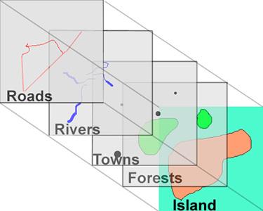
When the acetate is laid down over the map of the island and the corners are aligned, the roads appear to be in the correct location on the island. Now peel the roads acetate off of the map. Imagine the rivers are drawn in the same manner and peel them off of the map. Now the towns and now the forests, peeling back each type of data until all that is left is an outline of the island with no features. This is how GIS 'thinks' about data. Not only geographical data is treated this way; layers can be created which would represent the density and distribution of particular species on the island. Any data point that is tied to a real location on the face of the planet - including things which may seem transitory like animal movement (e.g. the number of Canada Geese passed over a given area of land per migration season) can be databased with a GIS. Different layers can be merged, combining all of their features, or intercepted, combining only the features common to both layers. The same can be done with complete maps (composed of many different layers). It is easy to see how such a tool can be used to investigate population dynamics on a very large scale.
There are two different categories of data features in a GIS, spatial data and attribute data. Spatial data is data that describes the geographic shape and position of features in the database. Spatial data is represented as either points, lines, or polygons. Attribute data describes spatial data. For example. A fence post is spatially a point. It may have the attributes of being constructed of wood or metal, or of being a corner post. The entire fence is spatially a line. It may have the attributes of height, direction, and type of fence (e.g. barbed wire, split rail, etc). The field bounded by the entire fence line is a polygon and may have the attributes of being rangeland or a cropping system, dryland or irrigated. Biological data can be considered attribute data of a sample site.
Data input can be accomplished via a number of methods. Standard planar maps can be entered using a digitizing table. Digitizing is creating a digital data file from a non-digital format. Similarly, photographs and other images (including printed maps) can be digitized using a scanner. Importing these digital images into a GIS involve assigning them real-world location coordinates. Not every point on the image need be individually assigned a location; if several reference points are assigned, the GIS software can then calculate any other location on the image. This process is referred to as georectifying or registering an image.
GIS software packages vary greatly in price and abilities. They are available for almost all operating systems (i.e. UNIX, DOS, MAC, Window '95 & Windows NT). The price of a GIS is generally directly related to the abilities of the software. Some packages are oriented more for digital mapping and have only weak spatial analysis capabilities. Others are very complex programs that incorporate sophisticated statistical procedures, require considerable training and have steep learning curves. Choosing the right GIS for a job requires evaluating what is expected from the software and choosing a package with the appropriate features. GIS software is available from approximately $300 and runs into the thousands.
The power behind using a GIS as a database for biological data lies in locational reference. There are several ways of associating sample sites with their real earth location. For example, sample sites can be located on a map and the site coordinates extrapolated or surveying tools can be utilized from a set bench mark. However, the easiest method is probably using a Global Positioning System (GPS).
Some suggested reading on GIS:
- Understanding GIS - The Arc/Info Method. 1994. Environmental Systems Research Institute, INC. Redlands, CA
- Getting to know desktop GIS : featuring ArcView, the geographic information system for everyone. 1995. Environmental Systems Research Institute, Redlands, Calif.
- Decision making with GIS, the fourth dimension : Eighth Annual Symposium on Geographic Information Systems in forestry, environmental and natural resources management, February 21-24, 1994, Vancouver, British Columbia, Canada.
- M.F. Goodchild, B.O. Parks, L.T. Steyaert (eds). 1993.. Environmental modeling with GIS Oxford University Press.
- W.J. Ripple (ed). 1987. Geographic information systems for resource management : a compendium. American Society for Photogrammetry and Remote Sensing , Falls Church, VA.
Global Positioning Systems (GPS)
GPS is a world-wide, satellite-based radionavigation system, developed by the U.S. Department of Defense (DoD). The system consists of a constellation of 24 satellites (21 of which are active and 3 are spares), orbiting the earth at an altitude of 11,000 miles. These are called NavStar satellites and are constructed by the Rockwell Corp. Because it was designed as a military system to locate both friendly and enemy resources, the system was designed to function in spite of jamming and interference. In addition, their extreme altitude ensures that a number of satellites will be 'visible' from the ground almost anywhere on earth. The basis of the system is triangulation of satellite signals. A GPS receiver on the ground (sometimes referred to as a GPS unit) measures the distance from a satellite using the time it takes for a radio signal, sent from the satellite, to arrive at the GPS unit. The system is designed so that the location of the satellites in the sky is known and very accurate atomic clocks in the satellite transmit a time code as part of the signal. GPS receivers also contain a self-correcting clock which synchronizes to the satellites and compare the time coded in the signal to that indicated by their own clock and the difference is the length of time the signal took to be received. It is then a simple calculation to conclude the distance to the satellite. Theoretically, with signals from 2 satellites (whose location in the sky we know), we can find our location on the earth through triangulation. However, given the potential for the receiver clock to be of, three satellites are the minimum for calculating accurate locations (this invovles the self-correction mechanism in the receiver). Receiving 3 (or preferably more) satellites will correct for many of the error sources. Four satellites are required for 3 dimensional locations (i.e. locations including altitude). Even the lowest priced GPS units are capable of receiving at least 5 satellites.
The NavStar satellites transmit two very different coded signals. The first is the C/A, or Clear/Acquisition code (also sometimes called the civilian code). This transmits the signal received by all civilian GPS receivers. The other code, the P, or Protected code can be encrypted by the DoD in the event of war to prevent an enemy from using the system. This encryption guarantees that only U.S. military users can get access to it. The P-code is thought to be more accurate than the C/A-code as it is transmitted on a higher frequency. New GPS receiver designs, however, indicate this may not be the case. In addition, the DoD can degrade GPS accuracy with an operational mode called Selective Availability (S/A), which introduces an intentional timing error.
GPS receivers vary greatly in quality and price. Much of this variance depends on the accuracy of the receiver. Typical hand held units can cost from under $200 - $1000+ and are typically accurate from 10-100 m. and are available from a number of manufacturers.
Obviously, if GPS is used for surveying, the accuracies discussed above are unsatisfactory. There are ultra-precise techniques which enable non-military GPS units to achieve centimeter accuracy. One of these methods is called 'Differential Correction'. There are several different methods of differential correction, but all basically involve the same theory. A GPS receiver (the base station) is be placed on a known location on the ground (i.e. a benchmark) and calculates the error in the satellite signal. An error correction is calculated and transmitted via FM radio to the unit being used to calculate actual locations (the rover). The correction signal is called 'differential correction'. Differential correction signals have a standardized format which is called RTCM 104. Other methods of obtaining differential correction signal include a commercial satellite system and a number of companies offer differential correction signal broadcast on FM bands to which you must pay a subscriber fee. Using differential correction, it is possible to obtain sub-meter accuracy receiving only the C/A code. Many of the lower cost hand-held GPS receivers are now differential-ready (can accept differential correction signal). Some survey quality GPS receivers can receive the P code. These systems, however, are very expensive.
Which GIS/GPS Should I Use?
Choosing the appropriate GIS and GPS for a project is analogous to choosing the right tool for any other job. There is a wide variance in price and associated abilities and functions in both of these technologies. A project's needs should be evaluated and the appropriate equipment selected. There are some features which are helpful to have in these technologies regardless of the project.
A Geographic Information System should have methods of editing both spatial and attribute data in the database; approximately 80 percent of any GIS project involves making the spatial data useable. Importation of data should be well supported and filters for various data sources supplied. In addition, a GIS should have the ability to manipulate different map layers in at least the following ways: merging different layers from the same geographical area to form a new layer which incorporates all of the features of the original layers, merging different layers from the same geographical area into a new layer which incorporates only the features in common of the original layers, building a buffer area of a given size around any feature on a layer, and joining layers from different geographical areas. A GIS should also have the ability to query all features of it's database, including Boolean searches (e.g. Standard Query Language, SQL). The spatial analyses available should include methods of interpolation between sample points, estimating dispersal and aggregation of point patterns is useful ability, and performing tabular analyses of the database. Finally, a GIS must present the results of the process in a clear and understandable format. Graphics characteristics should include support for full color, a variety of symbols, fonts, line styles and fill patterns, and support for common color printers and plotters.
The cost of a Global Positioning System receiver is principally dependent on the accuracy required. Models start at under $200 and range in price to tens of thousands of dollars. Earlier considerations when purchasing a GPS involved tradeoffs between power consumption and accuracy, these have been resolved. All GPS receivers must receive signal transmission from at least 4 satellites to calculate an accurate position. Basically, the more satellites a GPS unit can receive, the more accurate will be it's calculated location. Even very inexpensive GPS receivers now track 8-12 satellites simultaneously, so this should not be an issue unless purchasing an older, second-hand unit. In addition, newer units also are multi-channel receivers, allowing a greater signal to noise ratio, allowing the unit to lock onto satellite signal under more adverse conditions and to track satellites which are almost on the horizon. These receivers also receive satellite signal continuously, allowing them to calculate position and velocity instantaneously. Some newer models still utilize an older technology called multi-plexing, meaning they use a single (or sometimes several) channels that rapidly switch from one satellite to the next. Multi-plexing receivers are generally not as accurate or as flexible as multi-channel receivers. The recent decreases in price and accompanying increases in performance in GPS receivers means that excellent field units are quite affordable. A field GPS receiver should be able to store and later download data. In addition, download capability should also follow the standard format (i.e. NMEA 0183 is a standardized download code for GPS). A field GPS receiver should also be 'differential ready', meaning it comes equipped to receive standardized differential correction signal (i.e. RTCM 104 format). In the U.S., the Department of Transportation is considering making differential correction signal available on a no-fee basis across the country. In addition, congress has recently been pressuring the military to remove the encoded error in the C/A code.
Using GIS and GPS in IPM
Through these two technologies we are now able to very accurately locate and map fields, crop production, and pest populations. These abilities offer advantages in both IPM research and implementation. Scouting and monitoring pest populations, predicting pest outbreaks and movement, identifying and categorizing patterns of damage, assessing the success and refining the application of control tactics can all benefit from GIS/GPS technology. Many of these applications are compatible with remote sensing methods. The ability to import and georectify digitized images makes GIS a useful partner with remote sensing. Indeed, GIS is an excellent tool to facilitate the analyses of remotely sensed data. Although the extent of weed infestations frequently are assessed by remote sensing techniques, insect and plant pathogen populations are generally too small to sense remotely and patterns of damage are generally used as indicators. Satellite imagery, aerial photography, and radar have all been used to estimate insect populations remotely.
Scouting, Monitoring & Mapping Pest Populations
Scouting and monitoring pest populations and making control decisions based on those population estimates is one of the bases for IPM. The ability to accurately and precisely map the density and location of pest populations has obvious advantages, especially in regard to application of control tactics.
Monitoring programs can now digitally map the location of sample sites (taken in the field with a GPS) and the resulting GIS layers can then be used to interpolate the pest population over the sampled area. This is not a new technique; interpolative techniques, without GIS, have been used to estimate populations. However, a GIS layer will not only estimate populations but can be linked to other similar layers throughout a region, resulting in regional maps which estimate pest populations. This technique is used when constructing state or region wide estimates of pest populations or crop damage.
Typically, sampling has been done on a field level but this might not accurately reflect the driving influences behind a pest population outbreak. Populations tend to function on much larger scales and immigration from population sources can greatly impact the pest population in a field. Temporal series of GIS map layers of the same area, each layer representing the same type of data from a different sample period, can show not only changes in pest populations but, when combined with biological and ecological knowledge of the pest, indicate if this is a reproductive response or movement. If the boundaries of the monitored area are wide enough, source populations responsible for subsequent re-infestations of fields can be identified.
Precision Application of Agrochemicals
Using GIS & GPS to map the populations of weeds and plant pathogens offer some very tangible practical applications. Weeds especially are likely to re-occur in the same o neighboring area in a field. Consequently, mapping weed beds in a field during harvest and using this map to direct application of pre-emergent herbicide the following year can lower the amount of herbicide used in a production system. This technique is being incorporated into many brands of agricultural machinery. Pest populations and crop yields are mapped for particular fields and appropriate agrochemicals (pesticides and fertilizers) can then be applied only to the spot within a field that require them. GIS software is linked to the application equipment and is used to activate and stop spray nozzles. Using a computer to analyze a variety of inputs from environmental sensors, the system can compensate for many influencing factors (e.g. decrease drift and overspray resulting from wind). This is the process of precision agriculture. Although the original outlay in the cost of the technology can be high, many high value cropping systems are already incorporating both GIS & GPS. There is considerable data indicating that such technology can provide improved control of pests using significantly less chemical.
Using GIS to apply insecticides is possible but perhaps less cost-effective than its use with either herbicides or fungicides. Insects are much more vagile and within field distribution may vary year to year. However, certain trends in insect population distribution can be easily demonstrated using GIS. Certain insect pests track patterns in resource availability or are regularly reintroduced after localized extinction because of prevailing weather patterns. The factors responsible for both of these situations can also be incorporated into GIS databases and because the software can examine spatial relationships between items in the database, it can be used to develop predictive models. For example, the species composition of grasshopper complexes in the interface of dryland, irrigated and rangeland agroecosystems vary over the growing season. Different species occupy the different cropping systems at different times through the year. Preliminary data suggest this is because the different species are tracking various resources through the summer and into the fall (see example). The situation in the example was clarified from examining GIS maps of the temporal distribution of individual grasshopper species present in each of the neighboring agricultural systems. From the GIS database and resulting maps, we are able to see when and where both monitoring and control applications must occur to be effective.
Conclusion
GIS and GPS can provide us with the ability to very accurately map a production area and everything in it, including pest populations. The software can be linked to agrochemical application equipment to precisely apply pesticides and fertilizers only where such chemicals are needed. This can not only decrease the chemical load in the environment but can also result in better pest control at lower overall costs. In addition, this technology can be used to refine understanding about the distribution of pest populations and therefore target both monitoring and control tactics. The usefulness of these technologies in IPM, both in combination and alone, increases with proficiency in their use. The investment in adopting these systems, in purchase costs and time invested overcoming the significant learning curve of some packages, means they should not be taken on lightly. Like any other tool, GIS and GPS can offer unique solutions to certain types of problems but can cause others. In the case of using GIS in research, for example, it should be realized that GIS is an excellent tool for defining hypotheses, but deriving conclusions from any existing database without validation from a separate data source I considered data-mining. However, once adopted and in place, they can be used for much more than simply monitoring populations and control applications. They can be used to analyze the most efficient travel paths for machinery and delivery of products, the offer some obvious benefits to evaluating crop varieties by location, and they have tremendous potential in land management. There are other uses which have not been mentioned, and new uses will continue to evolve the more widely used these systems become.